Skip to content

Nutty Badgers ESU

The USL PEAKS Challenge

But have you got what it takes, to go for the Ultimate .......?

The Challenge is to visit all 10 waypoints .

  • Start & Finish – Upton St Leonards, Village Hall – the main gates.
  • The footpath handrail at the bottom of The Portway (near the Lower Lodge).
  • The Top of Portway, the BT pole post on the left as you go up the hill.
  • Cud Hill – the viewing point.
  • Painswick Beacon – the metal bench on the west side (overlooking USL) just down from the trig point, but if you get this far go the extra paces to the very top.
  • Coopers Hill –  the top of the hill, along the footpath heading south (in the clearing just up past the Cheese Roll).
  • Nut Hill – the gate at the top, but you still need to visit the top of the Hill.
  • Buckholt Wood – the top of the Cotswold Way, behind the green Natural England – Buckholt Sign).
  • Kites Hill – the top (this is not so easy to find) its on a tree stump, partly covered in ivy.

With detours recommended for

  • Spoonbed Hill
  • Cheese rollers
  • Prinknash Abbey grounds, garden, café, Monks walk,

The Ultimate USL Peaks Challenge

The Ultimate USL Peaks Challenge depending on the route you take is approx. 10miles, you have to

  • visit all the waypoints all in one walk on the same day.

  • you must visit The Lodge and The Top of Portway in succession, (it doesn’t matter which way).

  • to ONLY use a footpath or road once.

  • to not cross over a footpath or road you have already used.

  • to log in using the QR codes which are at each waypoint or to log in at the start of the walk and then send your walking App gpx data file for verification.

  • If you are on Facebook to mention you have completed the Challenge on the USL Community group…. Its for fun.

USL Peaks Challenge

The USL Peaks Challenge is to: –

  • visit all the waypoints in your own time.

  • to log in using the QR codes which are at each waypoint.

  • To enjoy the views and explore our footpaths.

  • Log into each waypoint as many times as you want.

  • Don’t forget to mention the locations and the Challenge on the USL Facebook Community group…. Its for fun.

The Getting Around - Navigation.

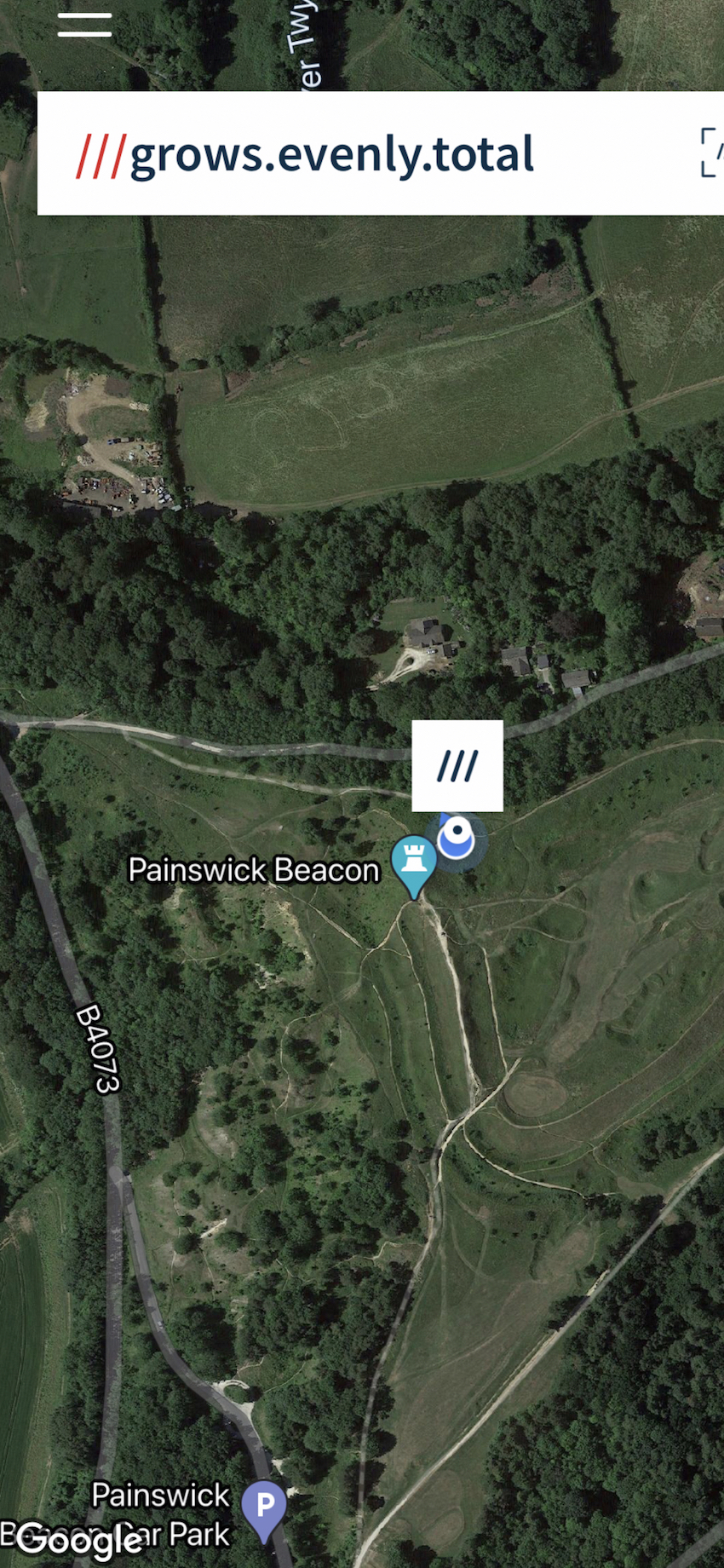
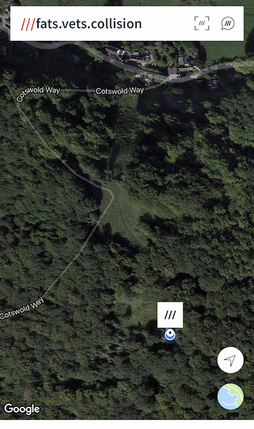
At each waypoint we have provide the Ordnance Survey Mapping Grid reference plus the What3Words reference, this ref is prefixed with  ///.
Both can be used to navigate to the waypoints. Plus Mobile phone Apps can be downloaded to assist. See logos below and links to their websites.
Also routes of other walks can be found on the Nutty Badgers website ‘Walks Around the Village’  and also in the USCAN Village Walks booklet. However, there is NOT a designated route for the Peaks Challenge, that is up to you.
If you don’t know how to navigate, now is the time to learn, with plenty of resources on the internet.
Recommended OS Map
What3Words - Click on logo to go to website
OS MAPS - click on logo to go to website

Important Information

Notes for all walkers: –

  • You are responsible for your own action/s and of those walking with you.
  • These walks can and will be demanding for persons at any time of the year.
  • There is no organiser / organisation setting these challenges, hence No responsibility is accepted from the person setting this challenge.
  • Please remember its just a bit of fun, enjoy the scenery and the great outdoors in and around Upton St Leonards.

Remember

  • The Highway Code,
  • The Countryside Code,
  • Keep to the public rights of way,
  • Respect the property and land of others,
  • If walking within the Prinknash Abbey grounds keep to the permissive routes at all times, adhere to the no dogs sign,
  • And good old common sense.

More details on the Waypoints

Each Waypoint will have a white sign and a QRcode. Scan the QR code with your phone. Most mobile phone scan when the camera is on. Point the camera scree at the QR code, a pop up box will appear. Click on this box on the screen and enter your details into the google form. It’s as simple as that.

So where are the waypoints and QR codes, below are the location.

Clicking on the ///what.three.word will open in a new page showing the location.


If you find any missing waypoints please let me know. Via the email  links on this website under Contact Us.

The START and FINISH waypoints are in the notice board at the Village Hall.

If participating on the ULTIMATE CHALLENGE you MUST log into the start QR code.

OS ……SO863148

///parent.sings.hotels 

The Lower Lodge – on the handrail of the footpath up the bank.   

OS: SO872138

///clocks.fairly.snake


Portway – on the BT pole at the top of Portway Hill

SO880129.

///digit.custom.pasta

altitude 226m

Kites’ Hill – is at the top of the hill, its on a tree stump which is partly covered in ivy.

SO877129

  ///inch.honest.dare

altitude 256.9m

Painswick Beacon – on the back of the metal bench, on the west side of the Beacon looking toward USL.  

SO868121  

///grows.evenly.total

altitude 273m at the bench

Cud Hill 

To the left of the view point display board.    

SO860125

///about.audio.dragon

altitude 271m

Buckholt – is at the top of the Cotswold Way –

on the rear of the Natural England sign.

SO886135

///ruffling.broached.ivory


Coopers Hill – this is on the footpath leading south from the main cheese roll hill.

As you walk south up to and through the clearing, the top of the hill is just there. The Waypoint is wrapped around a tree to the left.  

SO892145

///fats.vets.collision

altitude 275m

Nut Hill – whilst the top is where the stone marker is, there is no where sensible to put the waypoint. So its on the wooden post on the gate at the top of the track from the route up from Bowden Hall. However, you still have to visit the top of the hill…!

SO872151

The waypoint is here:-

///upgrading.folds.gravel

Have fun, take nothing but photos, leaving nothing but footprints.

If you locate any missing waypoint signs please let me know via the main website contact page.
Please put photos on the Upton St Leonards Community Facebook pages #USLPeaksChallenge
Enjoy the Challenge.
…………….Stewart


The maps used on this page are used under the free share agreement from Ordnance Survey Crown Copyright.